Project Description
CleanRoute
Commuting to work sustainably is hard. Currently there is no app or service within Australia that allows commuters to discover and plan sustainable commutes and with the impending deadline of net zero by-2050, we must all play a part in ensuring that we make the most sustainable decisions.
We beleive that this app and help cut carbon emissions in Australia as well as helping Australian citizens with getting around with the easiest, cost efficent and eco-freindly way.
Click here to view our Video
About the App
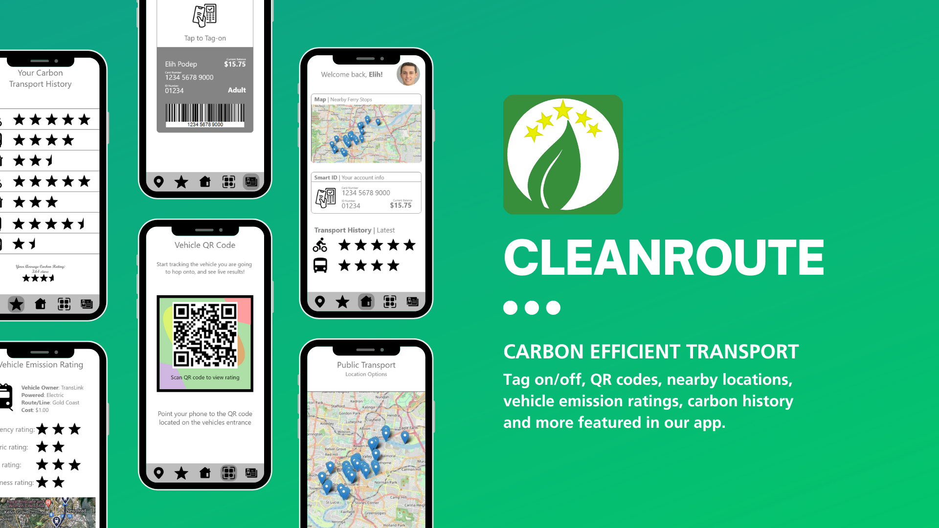
It is a purpose-built application allowing citizens to plan their travel with sustainability in mind. Citizens can enter their destination and they are presented with a list of sustainable travel options ranging from renting a bike to catching public transport, each with a corresponding star rating on how carbon efficient the route is. These ratings are calculated in real time based on all available data sources. (Please read data story for more info)
In-app Features
The app also features tag on/off functionality when using public transport, meaning that users don’t need to bring their transport pass. QR codes can also be placed on transport options allowing users to scan them and learn more about the environmental impact of the transport option.
Users can then view their carbon summary report every few weeks allowing them to quantify how much carbon they have saved.
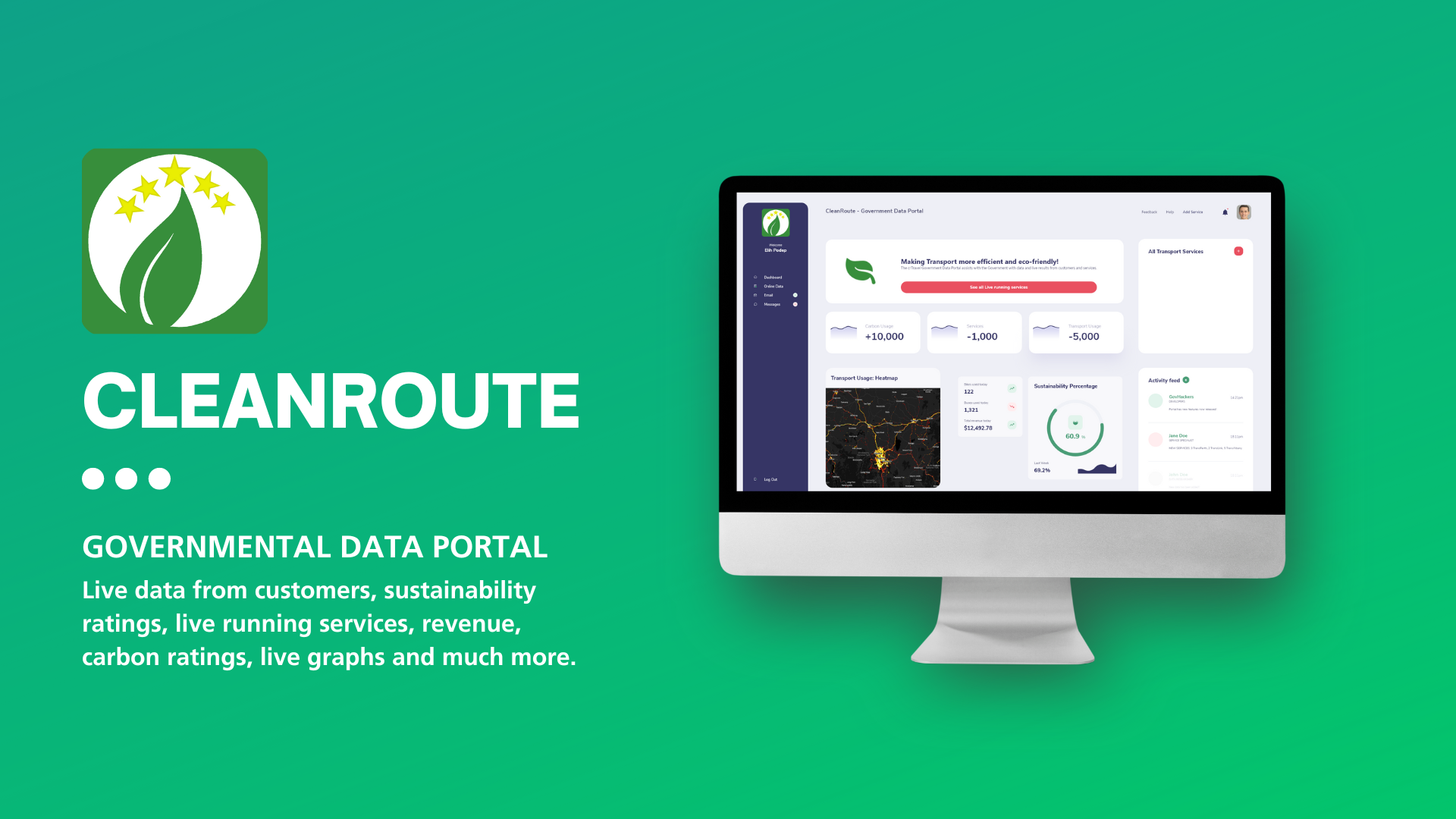
Goverment Data Portal
Our project also has a goverment portal which lets staff and govermental staff see live data from customers, sustainability ratings, live running services, revenue, carbon ratings, live graphs and much more. (Please read data story for more info)
Data Story
The application is a map/GIS application which incorporates open data from various data sources:
- Static open government data provides location information regarding bus, train, tram, and ferry stops/routes and eBike data such as charging and hiring stations. (Brisbane bus locations, NZ bus routes)
- Real time information from various state tag on/off systems allowing the application to dynamically generate ratings based on the current transport network patronage. This is useful in scenarios where a bus service or route is underutilized, the app will redirect patrons to the underutilized service, therefore increasing the carbon efficiency of the route. (NZ bus patronage, also could include custom JSON live-stream from ticketing services.)
- Internal data sources such as people tagging on/off using the app and users that are scanning the QR codes to find out more information, can be used to determine loading of services and further improve recommendation accuracy.
- Roadworks/infrastructure maintenance and construction can also be included to ensure commuters make it safely to their destination while remaining carbon efficient.
All data sources in the user application are GeoJSON based and rendered on a Mapbox map.
The application also has a government interface that allows the monitoring of:
- Public transport route efficiency. Less efficient routes are flagged, and automated recommendations are generated depending on the frequency and patronage, allowing government organisations to further optimise their public transport systems.
- Provides a succinct overview of all forms of transport, usage statistics for each, carbon footprints and most importantly automatic improvement recommendations which can be implemented.
The government portal also is a useful tool in evaluating community response to transport projects, large and small.
Other potential ideas include:
- Gamification, “by using this route the efficiency increases by 1 star”. The user can then collect stars to form a star collection which can be spent to fund sustainability initiatives or purchase sustainable products.
