Flood Risk: Understanding the impact of climate change on extreme weather events in Hobart
Jurisdiction: Tasmania

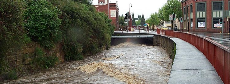
Hobart, Tasmania is prone to extreme weather events, especially flash flooding.
How can we better understand the risk of flooding and build a robust model to illustrate the increasing regularity and intensity of flooding?
What would the impact of coincident events look like?
How can we develop a collaborative flood warning and alert system for Hobart?
Flood Risk: Understanding the impact of climate change on extreme weather events in Hobart
Climate change is a global, national and a local issue which is expected to impact Hobart’s natural environment, economy and liveability. Hobart can also expect changes in the frequency and magnitude of extreme weather events such as flooding.
Hobart is located at the foot of kunanyi/Mt Wellington and this can mean that Hobart is susceptible to flash flooding. Flash floods are characterised by fast rising and fast receding water. Flood waters are often shallow but fast moving. When a high tide occurs at the same time as an extreme rain event, flooding can be even worse.
The major waterways of Hobart include Hobart, New Town and Sandy Bay Rivulets. These major waterways have water flowing in them permanently and have high natural amenity. Residents and visitors to Hobart may be unaware of the City’s minor waterways or natural drainage lines. Many of these have been piped, and many are dry for some or all the year. Some of the minor natural drainage lines may only have water flowing in them in extremely heavy rainfall events.
How can we build a robust model to assist with development of communications about the heightened risks of flooding?
How can we communicate and educate the community simply and effectively about the importance of food risk?
How can we develop a cooperative flood warning and alert system for Hobart?
Can a model of extreme weather events be developed to predict and illustrate the increasing regularity and intensity of flooding and other extreme events?
How can we develop a tool for effective flood risk planning, management and prevention?
Integrate City of Hobart data sets and other data sources into a tool to help drive sustainable flood management and prevention for the future.
Please note detailed data has been supplied for Hobart and New Town Rivulet only.
Additional Information:
Other Data:
sdi.tas-hires-weather.cloud.edu.au GeoServer rainfall
https://sdi.tas-hires-weather.cloud.edu.au/geoserver/web/wicket/bookmarkable/org.geoserver.web.demo.MapPreviewPage?8&filter=rainfall
Elvis - Elevation and Depth - Foundation Spatial Data
https://elevation.fsdf.org.au/
BOM
http://www.bom.gov.au/climate/data/
http://www.bom.gov.au/climate/cdo/about/cdo-selecting-data.shtml
http://www.bom.gov.au/tas/flood/index.shtml?ref=hdr
CSIRO
https://data.csiro.au/collection/csiro:12861
ABS
https://www.abs.gov.au/AUSSTATS/abs@.nsf/DetailsPage/2033.0.55.0012016?OpenDocument
https://www.abs.gov.au/ausstats/abs@.nsf/Lookup/by%20Subject/2033.0.55.001~2016~Main%20Features~IRSD%20Interactive%20Map~15
Other relevant Documents:
City of Hobart: Stormwater and urban waterways
https://www.hobartcity.com.au/City-services/Stormwater-and-urban-waterways
City of Hobart: Understanding flood risk
https://www.hobartcity.com.au/City-services/Stormwater-and-urban-waterways/Understanding-flood-risk
City of Hobart Flood Fact Sheet for Residents
https://www.hobartcity.com.au/files/assets/public/city-services/stormwater-and-urban-waterways/flood-fact-sheet-for-residents.pdf
City of Hobart Flood Fact Sheet for Developers
https://www.hobartcity.com.au/files/assets/public/city-services/stormwater-and-urban-waterways/flood-fact-sheet-for-developers.pdf
City of Hobart Flooding Guide
https://www.hobartcity.com.au/files/assets/public/city-services/stormwater-and-urban-waterways/flooding-guide.pdf
Connected Hobart: Smart City Action Plan
https://www.hobartcity.com.au/files/assets/public/strategies-and-plans/hcc4578-smart-cities-action-plan-a3-single_110919.pdf
Image credit: City of Hobart 2022.
Eligibility: Use one or more datasets from CoH Open data portal and ensure the submission relates to understanding flood risk in the city of Hobart.
Entry: Challenge entry is available to all teams in Australia.
Dataset Highlight
Bureau of Meteorology climate data
BOM Tasmania Rainfall and River Conditions data
Elvis - Elevation and Depth - Foundation Spatial Data
GeoServer rainfall data
Shoreline erosion vulnerability - Land Information System Tasmania
TasWater Flood Inundation Summary - Land Information System Tasmania
Real-time accumulated rainfall map of Tasmania - Land Information System Tasmania
Land Information System Tasmania - Monthly average rainfall
Layer: Facilities Zoom in
LIST Cadastre and Administrative (Localities-Postcode):
LIST Topography and Relief:
LIST Orthophotography 2019
City of Hobart New Town Flood data with 20%
City of Hobart Flood data with 1%
City of Hobart New Town Flood data with 10%
City of Hobart New Town Flood data with 5%
City of Hobart New Town Flood data with 1%
City of Hobart Flood data with 20%
City of Hobart Flood data with 10%
City of Hobart Flood data with 5%
City of Hobart Elevation - Contours 0.50
City of Hobart Elevation - Contours 0.25
Flood Prone Hazard Areas Code
Hobart Interim Planning Scheme 2015 Overlays
Hobart Interim Planning Scheme 2015 Zones
Stormwater Network
Open Space Parks
Recreational Tracks and Trails
City of Hobart : Base Road Assets
City of Hobart: Road Formation
City of Hobart: Trees Parks and Street
ENVIRON Significant Tree Locations
Census of Population and Housing: Socio-Economic Indexes for Areas